Length
Total miles from trailhead and back, including any
loops or other deviations described in the dialog
|
Seasons
(Based on conditions rather than actual months)
| Winter |
= November thru April |
| Spring |
= May and June |
| Summer |
= July and August |
| Fall |
= September and October |
| All |
= all year access |
|
Permits
Trailheads that require a pass
Purchase Northwest Forest Pass Here
NWFP
Northwest Forest Pass Required |
Other
Other permits required - inquire before departure |
None
No permits required - can change without notice |
|
Elevation Change
Cumulative elevation gain in feet
|
Difficulty
 Easy Easy
small children, elderly, or physically challenged
trails are generally in very good condition
generally less than 300' elevation gain
generally less than 2 miles
|
 Moderate Moderate
young to elderly in good hiking condition
trails are generally in good condition
generally less than 1000' elevation gain
generally less than 6 miles
|
 Challenging Challenging
teens and older in very good hiking condition
trails are generally in at least fair condition
generally less than 2100' elevation gain
generally less than 12 miles
|
 Difficult Difficult
someone in excellent hiking condition
trails are generally in at least fair condition
generally less than 3500' elevation gain
generally less than 16 miles
|
 Very Difficult Very Difficult
someone in exceptional hiking condition
trails are not always easy to follow
generally less than 4100' elevation gain
generally less than 20 miles
|
 Extreme Extreme
someone in exceptional hiking/climbing condition
trails are not always available
extreme elevation gain or extreme mileage
technical aspects of hike
|
|
Hike Difficulty Calculator
|
A word about pets
Please be considerate of hikers, horseman, and
bikers when you make a decision to bring your
beloved pet with you on the trail. There are
times and places where a leash is appropriate.
And there may even be times when you should
not take your pet with you.
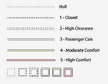
ROAD SYMBOLS

|
|
Trail Conditions
(Unrelated to weather or season)
| Excellent |
= logged out - good surface |
| Good |
= some debris/obstacles - good surface |
| Fair |
= a lot of debris/obstacles - surface issues |
| Poor |
= difficult to find/follow - poor surface |
| Special |
= unusual situation - call USFS before |
|
Horses
Yes / No /NR (Not Recommended)
Horses are often allowed in areas where mountain bikes
are not. And of course there are trails where horses
would not be safe.
Always be kind and courteous to our friends on horseback.
|
Trail Access
(Related to the roads used to get to the trailhead)
| Excellent |
= excellent - usually paved |
| Good |
= gravel - minimum potholes/washboard |
| Fair |
= gravel - moderate potholes/washboard |
| Poor |
= dirt - recommended for 4x4 |
| Special |
= unique circumstances - check first |
|
Mountain Bikes
Yes / No /NR (Not Recommended)
Mountain bikes are usually not permitted in
Wilderness Areas. And of course there are
some trails that just aren't suited for bikes.
Always be kind and courteous to our friends on bikes.
|
Signage
(Trail signs and markers)
| Excellent |
= readable signs where necessary |
| Good |
= readable signs in most places needed |
| Fair |
= missing/damaged/unreadable signs in places |
| Poor |
= almost no signs where needed |
|
Features
A description of the significant
features of this hike; such as views
lakes, rivers, wildflowers, etc.
|
Usage
(company refers to encounters with other people)
| Extremely Heavy |
= constant company |
| Heavy |
= frequent company |
| Moderate |
= occasional company |
| Light |
= rare company |
| Minimal |
= near solitude |
|
Please Read
Most of the measurements on this page are entirely subjective.
Each hiker has a different opinion as to what is easy vs. difficult;
What is good conditions vs. poor conditions; and so forth.
Also, it seems everyone's odometer and GPS provides
slightly different data. So, please be understanding if the
information you read on this CD doesn't fit your own.
|


 Easy
Easy
 Moderate
 Challenging
 Difficult
 Very Difficult
 Extreme
