Length: 4.6 miles round trip to lake and back
Elevation Change: 800' elevation gain
Season: Late spring thru Fall
Difficulty: Moderate to lake
Length: 11 miles round trip to Hunts Cove
Elevation Change: 2000' elevation gain
Season: Summer thru Fall
Difficulty: Challenging
Permit: Special Pass Required - Online Reservation
Features:
This is one of the most popular hiking
destinations in the Mt Jefferson Wilderness
area. After one visit, you'll see why. This place is
just plain fantastic!
Keep in mind you must obtain a special use
permit to hike/camp in the Pamelia Lake / Hunts
Cove area of the Mt Jefferson Wilderness.
Pamelia Lake or Hunts Cove Limited Entry Permits
in the Detroit Ranger District of the Willamette National Forest must be
obtained on line at www.recreation.gov
or by calling the Reservation Line at 1-877-444-6777. If a person wants to get the
permit on the day of the hike, they can call it in and stop by the Detroit Ranger Station
and they will print their permit for them.
Cost: $6.00
Summer hours: 7 days a week 8-4:30 Memorial Day
thru Columbus Day
Regular hours: Monday-Friday 8-4:30
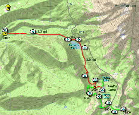
The trail to Pamelia Lake begins fairly gently
as it follows Pamelia Creek most of the way
to the lake. From time to time you will have
excellent opportunities to enjoy the creek
and it's beautiful cascades.
At about 2.3 miles you will come to the shore
of Pamelia Lake. Your first sight of this
gorgeous lake can be overwhelming, depending
on the weather and season.
The main trail parallels the lake on the east
side a bit distant from the shore, so you might
want to take the user trail that follows very
closely to the shore for better views.
At the far end of the lake the trail continues
upstream until a convient crossing of logs, rocks,
or just plain wading. Use caution.
The trail up to Hunt's Cove becomes much steeper
than the hike so far, so be sure to have plenty
of water and be prepared for a long steep climb.
As you near the top of the basin, there is a
great little falls off to the side of the main
trail that is worth a peek. You just follow a
users trail a few feet off the main trail to see
the falls.
Soon you will come to to a junction of a trail
that will take you to the ridge above Hunt's Cove.
I recommend that you go the lake(s) first, then
consider the climb to the ridge above for unparalleled
views of Mt Jefferson and Hunts's Cove below.
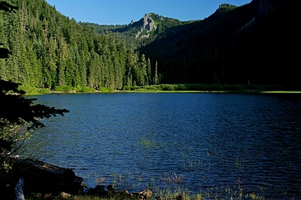
Looking toward Hunts Cove from Pamelia Lake
|