
|
THE FOLLOWING MAP IS NOT TO BE USED FOR NAVIGATIONAL PURPOSES.
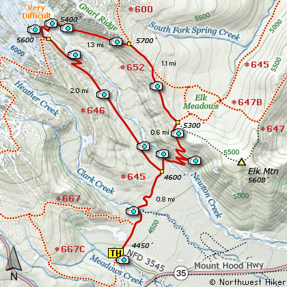
Map of the Gnarl Ridge, Newton Creek Hike
|
Length: 8 miles round trip
Elevation Change: 1400' gain
Season: Early Summer thru Fall
Difficulty: Challenging
Permit: NW Forest Pass Required
Features:
NEW!
Click for PDF Topo Map of this Hike
The Newton Creek Loop Hike is an enjoyable summer hike with outstanding
views and floral displays. The hike begins near the Mt Hood Meadows Sno Park area and travels level for nearly the first
mile. Like the Gnarl Ridge Hike, the most difficult part of the hike is crossing Newton Creek.
However, on this hike you have to cross Newton Creek twice. The water is
fast and depending on the time of year or current weather conditions, the water can
vary greatly in depth. Use caution crossing. After reaching the north side of the
creek, the trail climbs vigorously for about a half mile through a series of 9 switchbacks.
At the top of the ridge, the trail intersects the trail to Bluegrass Ridge and Gnarl Ridge.
If you continue straight ahead, you will come to Elk Meadows. However, follow Trail #652
on your left up Gnarl Ridge toward Mt Hood.
In a little over a half mile you will pass the intersection of Trail #652A which also leads
to Elk Meadows. Continuing on you will come to the Timberline Trail #600. Follow this
trail to the left downhill toward Newton Creek. This is the point where you have to
cross Newton Creek again. This crossing always seems more difficult that the lower crossing.
Carrying wading shows in your pack is a smart idea. Use Caution.
After crossing the creek, the trail climbs up Newton Ridge where it intersects Trail #646. Follow
this trail downhill following Newton Creek. You will then complete the loop by joining
Trail #645 which takes you back to the trail head where you started the hike.

Mt. Hood as seen from the Newton Creek crossing
|
How to get there:
NEW!
Click for PDF Directions Map of this Hike
Follow Oregon Hwy 35 south of Hood River or
north from Hwy 26 near Government Camp until
you come to Road 3545 just a mile or so
north of the turnoff to the Mt Hood Meadows
Ski Resort. Turn on this short
access road for about a half mile and the
trailhead is on the north side along with
the parking space.
Note: This is the same trailhead for the
Mt. Hood Meadows Loop hike, the Elk Meadows hike,
the Newton Creek Loop hike and the Lamberson Butte/Gnarl
Ridge hike.d.
|
|
|
A Virtual Hike of the Mount Hood National Forest


|
|


