
|
THE FOLLOWING MAP IS NOT TO BE USED FOR NAVIGATIONAL PURPOSES.
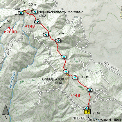
Map of the Grassy Knoll, Big Huckleberry Mountain Hike
|
Length: 11 Miles round trip
Elevation Change: 1400' Elevation gain
Season: Late Spring thru Fall
Difficulty: Challenging
Permit: NW Forest Pass Required
Features:
This hike description is actually two
hikes in one. The first part of this
hike takes you to a destination in its
own, Grassy Knoll. The remainder of
this dialog takes you on to Big
Huckleberry Mountain.
The trail begins just off Forest Road
#68 and begins climbing immediately.
The trail climbs steadily through dense
forested areas as it makes its way to
a outstanding viewpoint about a mile
into the hike.
The trail works its way over to the
edge of an uplift where you get
fantastic views of a lava flow valley
and Mt Adams peeking out from behind
Little Huckleberry Mountain.
In season, this hike is about as
floral as it gets.
Shortly after the trail reaches the
ridge line of the uplift, you will
find yourself looking up at Grassy
Knoll. The trail gets steeper at
this point, but its only a short
climb to the top of the knoll. Here
you are treated to excellent views of
the Columbia River Gorge and Mt Hood
peeking out from behind Mt Defiance.
This place on the hike is a worthy
destination in itself, but for those
who want more of a challenge, just
retrace the last couple hundred feet
of the trail and bear left on the
trail that leads up the ridge line.
This ridge line trail will take up
through floral meadows with wonderful
views of the surrounding terrain.
At about 3 miles into the hike, the
trail takes a left turn into a densely
forested area where you will remain
for the next couple miles. This part
of the trail wanders up and down in
elevation, eventually climbing steeply
to meet the Pacific Crest Trail #2000.
As soon as you meet the PCT, you will
leave it by follow a spur trail to
the right which leads to the top of
Big Huckleberry Mountain.
When you reach the top you will be
treated to excellent views of Mt Adams
to the northeast, and Mt Hood to the south.
In season, this too is a floral garden.
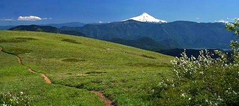
Mt Hood Oregon as seen from Grassy Knoll
|
How to get there:
NEW!
Click for PDF Directions Map of this Hike
From Portland, OR
From Portland, travel east on Interstate Hwy 84 to Exit 44 to Cascade Locks.
Exit the freeway and cross over the Columbia River into Washington
via the Bridge of the Gods. Then turn right, or east, and head
east through Stevenson, Washington to the intersection of the Wind
River Highway to Carson, Washington. Bear left onto the Wind River
Highway which will take you through Carson, Washington.
from Vancouver, WA
From Vancouver, WA travel east on SR14 through Stevenson, Washington to the
intersection of the Wind River Highway to Carson, Washington. Bear left onto
the Wind River Highway which will take you through Carson, Washington.
from Carson, WA
About 4 miles from SR14 you will come to the Bear Creek Road on your right.
Turn right onto this road and follow it east. It will become Forest Road 6808.
Continue on this rugged gravel mountain road for about 10.8 miles from
the Wind River Highway and you will come to a junction with Forest Road 68.
Bear left at this point onto FR68 and follow this seasonally rough road
for about another 2 miles. Then on your right you will see the parking
area and trailhead for this hike.
|
|
|
A Virtual Hike in the Gifford Pinchot National Forest


|
|


