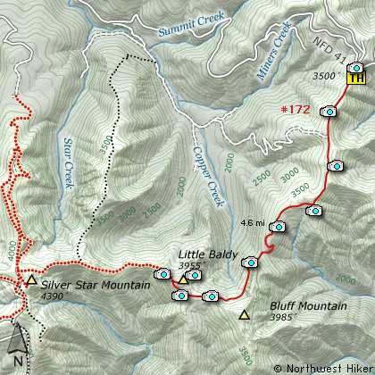
Length: 9.2 Miles round trip
Elevation Change: 1255' Cumulative Elevation gain
Season: Late Spring thru Fall
Difficulty: Challenging
Permit: No Pass Requirement
Features:
This hike begins off Forest Road
#41. The trail follows an old
road for the first couple
miles along a ridge line.
This entire area was burned
severely in what is known as
the 1902 Yacolt Burn. Even today
you can see the attempts to
replant the forest from decades
ago.
The area was burned so badly
that it has never fully recovered.
As you hike along this trail you
can plainly see small ridges built
to hold moisture and the newly
planted trees in an attempt to
restore the forest.
After leaving the parking area,
the trail climbs gently along a
ridge following the old road bed.
Views along this stretch of the
hike are great. You can see Mt
Adams to the northeast, Mt Hood to
the southeast, and Mt St Helens to
the north. In season this is a
very floral hike.
After a couple miles, the road ends
and the trail continues. The trail
looses some elevation at this point
as it works its way over to Bluff
Mountain. After crossing the saddle
between ridges, the trail climbs
steeply along the western side of
Bluff Mountain. The views of Little
Baldy and Silver Star Mountain are
spectacular.
As the trail works its way to the
west side of Bluff Mtn, it enters
a dense new-growth forest. When
it emerges, the trail climbs steeply
before leveling off on the south side
of Little Baldy Mountain. Here you
are treated to views of the Columbia
River Valley to the south and Silver
Star Mountain directly in front of
you to the west.
The trail crosses the southwestern
flank of Little Baldy in an open
rocky area. When it reaches the
ridge line directly west of the
mountain, you can scramble to the
top of Little Baldy by just following
an old trail that is still evident.
From the top of the mountain you
have outstanding views of all the local
Cascade Volcanos - Mt Hood to the
southeast, Mt Adams to the northeast,
Mt Rainier to the north, and Mt
St Helens to the northwest.
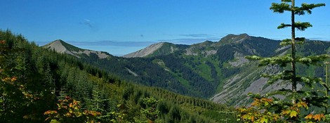
Little Baldy Mountain and Silver Star Mountain
|
How to get there:
NEW!
Click for PDF Directions Map of this Hike
From Battle Ground, WA
Travel north from Battle Ground, WA on SR503 for approximately 5.6 miles to the
Lucia Falls Road. Turn right and follow this road for about 8.5 miles east to the
Sunset Falls Road. Continue east on the Sunset Falls Road, which will become
Forest Road 42, for 7.3 miles where you need to turn right onto Forest Road 41.
Follow FR41 through the Sunset Campground and across the East Fork of the Lewis River.
Continue on FR41 for about 3.3 miles and you will come to the intersection of FR4109.
FR4109 will take you to Silver Star Mountain, but for this hike, continue on eastward
for another 5.6 miles, which will bring you to a wide open ridgeline and the trailhead
for Little Baldy Mountain and the eastern approach to Silver Star Mountain.
|