

|
THE FOLLOWING MAP IS NOT TO BE USED FOR NAVIGATIONAL PURPOSES.
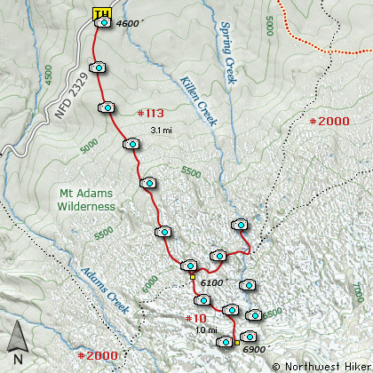
Map of the Killen Creek, High Camp, Mt Adams Wilderness, PCT Hike
|
Length: 8.2 Miles round trip
Elevation Change: 2300' Elevation gain
Season: Mid-Summer thru Fall
Difficulty: Challenging
Permit: NW Forest Pass Required
GPS: N46 17.31, W121 33.15
Latitude: 46.2885
Longitude: -121.5525
Features:
This hike begins off Forest Road #2329.
There is a large parking area and this
hike is very popular for hikers and
horseback riders.... and mosquitos.
The name of this hike is a bit
misleading. The trail follows a
ridge line almost the entire distance.
Having said that, the trail begins
climbing right out of the parking area.
The trail climbs so steeply in places
that steps have been put in place to
decrease the erosion. One of the main
reasons that this hike is so popular are
the tremendous wildflower displays.
The trail climbs steeply for the first
two miles, and is mostly in dense forest.
Eventually, you break out into meadowed
areas with vast wildflower displays.
There are a number of small streams to
cross as you continue toward Mt Adams.
As soon as you enter these more open
areas you are treated to fantastic views
of Mt Adams right in front of you and
Mt Rainier in the distance to the north
which is directly behind you.
At about 3 miles you come to the junction
of Pacific Crest Trail #2000. To continue
on to the High Divide Camp, bear right for
a hundred feet or so and you will see the
less used trail heading directly toward
Mt Adams.
This part of the trail becomes much
steeper and harder to follow, depending
on the season you are there. It is
about another mile of steep rocky
climbing to the place called High Camp.
This extra part of the hike is so
worth the effort. You will find
yourself on the very flank of Mt Adams,
surrounded by more beauty than the
eye can behold.
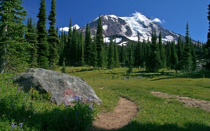
Mt Adams as seen from the Killen Creek trail
|
How to get there:
NEW!
Click for PDF Directions Map of this Hike
From Portland, OR
From Portland, travel east on Interstate Hwy 84 to Exit 64 at Hood River.
Turn left, and pass under the freeway and cross the toll bridge ($2.00)
into Washington state. Turn left onto SR14 and drive approximately 1.5
miles to state road 141 Alt. Turn right onto SR141 Alt. and follow it another
2 miles and merge bearing left onto SR141. Then travel north on SR141
for another 19 miles to Trout Lake and the junction to Mt. Adams Road. Bear
right and forward onto Mt. Adams Road for about 1.3 miles and you
come to the junction with Forest Road 23. Bear left and ahead
onto FR23 and continue north for about 19 miles and you will come
to the junction with Forest Road 90. Take a sharp right uphill turn
and continue on FR23. At this point the road becomes very rough
surface and you will follow this road for just under 3 miles. You
then come to the junction of Forest Road 2334. Bear right and continue
on FR23 for another 1.4 miles. You will then come to the junction
with Forest Road 2329. Bear right and straight ahead onto FR2329.
FR2329 is paved for the next mile, but don't get used to it. It
turns to gravel again for the remainder of the journey. After leaving
FR23 you will travel about 5.8 miles and come to the trailhead for
Killen Creek on your right.
|
|
|
A Virtual Hike in the Gifford Pinchot National Forest


|
|


