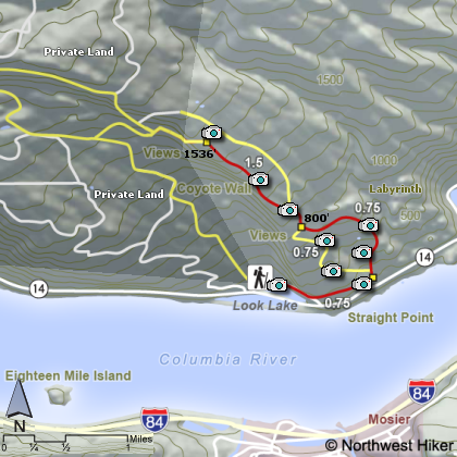
Hike 58
The Columbia River Gorge National Scenic Area
Coyote Wall Hike
Search West Hikes West Central East Central East Hikes
Home Page
Main Map


Click to view product details

THE FOLLOWING MAP IS NOT TO BE USED FOR NAVIGATIONAL PURPOSES. Coyote Wall Hike map
Map of Coyote Wall Hike

Length: 8 mi loop
Elevation Change: 1700' total gain
Season: Almost Year Round
Difficulty:    Challenging
Permit:   Pass Not Required
GPS:   N45 42.03, W121 24.144
Latitude:   45.7005
Longitude:   -121.4024
Features:


NEW!
 Click for PDF Topo Map of this Hike 

The Coyote Wall area is becoming very popular among hikers as they discover the incredible floral displays that are seen here each early spring. There are a number of ways to explore the Coyote Wall area and the wonders of the Columbia River Gorge and the floral displays often found only on more difficult terrain.

The map above shows there are several trails along Coyote Wall from which to choose your route. In mid-May the flowers are usually the best. But the photos will give you an enticing view of the Coyote Wall area and hopefully will inspire you to venture forth on your own excursion and find the rich rewards available in this newly developed area.


Floral Displays along the Coyote Wall trail

How to get there:

Drive I-84 east. Take Exit 64 in Hood River for Hwy 35, White Salmon, and Government Camp.

After exiting, turn left and drive north over the Hood River Bridge ($2 toll) for 1.2 miles.

Turn right on Washington Highway 14 E for Bingen and White Salmon and drive 4.7 miles through Bingen, making a left on Courtney Road.

Immediately turn right into the Coyote Wall Trailhead parking area.


Hike Difficulty Calculator

Calorie Burn Calculator

The 10 Essentials
Bear Encounters

Cougar Encounters

River Crossing Safety
A Virtual Hike of the Columbia River Gorge National Scenic Area


Click to View Instructions