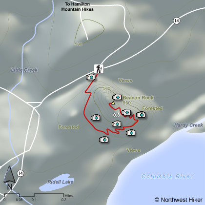
Hike 27
The Columbia River Gorge National Scenic Area
Beacon Rock Hike
Search West Hikes West Central East Central East Hikes
Home Page
Main Map


Click to view product details

THE FOLLOWING MAP IS NOT TO BE USED FOR NAVIGATIONAL PURPOSES. Beacon Rock Hike map
Map of Beacon Rock Hike

Length: 1.6 miles round trip
Elevation Change: 750' gain
Season: Year Round
Difficulty:    Moderate due to steep climb
Permit: Washington requires a Discover Pass day-use fee
GPS:   N45 37.7454 W122 1.2618
Latitude:   45.62909
Longitude:   -122.02103
Features:


NEW!
 Click for PDF Topo Map of this Hike 

A fun and interesting hike for the whole family. The parking area is located along Washington Hwy 14, so the access couldn't be easier. HOWEVER, at this moment, the state of Washington has decided to charge you a day-fee for parking and enjoying this area.

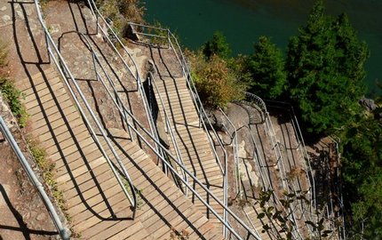
The trail is "fastened" literally to the side of this unusual rock sitting on the banks of the Columbia River. The views from the top are excellent. Caution is common sense on the narrow trail.


Beacon Rock trail
Beacon Rock trail

How to get there:

Beacon Rock State Park: Cross Bridge of the Gods in Cascade Locks ($2 toll). Turn left/west onto WA Hwy 14. Drive 6.5 miles west to the trailhead on the left side of the road. You'll see Beacon Rock getting bigger as you approach. It's hard to miss. Discover Pass required here.

Alternatively, drive east on Highway 14. The trailhead is just west of milepost 35.


Hike Difficulty Calculator

Calorie Burn Calculator

The 10 Essentials
Bear Encounters

Cougar Encounters

River Crossing Safety
A Virtual Hike of the Columbia River Gorge National Scenic Area


Click to View Instructions